| |
Cresta
Vista, Boulder Creek, California 95006 USA |
| Lat: 37.140° Lon: -122.127°
Alt: 695 feet |
| CWOP Site ID: C1844
Wunderground ID: KCABOULD3 |
| Real-time weather data
updated frequently. |
|
Current Station Operational Status
10-23-2020 Installed air particle counters from PurpleAir and added widgets to the main page.
11-11-2020 Added PurpleAir Air Quality Index map of Boulder Creek to main page.
11-12-2020 Updated Space Weather page.
01-22-2021 Power outage took out the server's power supply despite it being on a UPS. Some pages will not be updated until repair is completed.
01-28-2021 Power supply replaced in weather server and back online. Repairing some webpages that gone off.
12-16-2021 Replaced failed air particle sensor display in webpage with new display. |
03-09-2023 Rain bucket offline. Suspect snow messed up the tipping bucket.
03-11-2023 Rain bucket failed with crud buildup. Rain totals are invalid. Hoping to climb the roof and clear it out.
08-17-2023 Rain bucket has been throughly cleaned. Dirt had plugged up the drip hole. |
|
|
|
|
|
|
| Chrome update of 76.0.3809.132 introduced a bug, which stretches horizontally all menus that contain left/right background images in their items. Let me know if this is an issue. |
|
|
|
|
|
|
Local Weather
Warnings and Forecasts |
|
|
      No Warnings

CAZ512-310900-
Santa Cruz Mountains-
1102 AM PDT Thu Jul 30 2026


.REST OF TODAY...Sunny. Highs in the lower 70s to mid 80s. West
winds around 5 mph.

.TONIGHT...Mostly clear. Lows in the 50s to lower 60s. Northwest
winds around 5 mph in the evening...becoming light.

.FRIDAY...Sunny. Highs in the mid 70s to upper 80s. Light winds...
becoming west around 5 mph in the afternoon.

.FRIDAY NIGHT...Mostly clear. Lows in the 50s to mid 60s.
Northwest winds up to 5 mph.

.SATURDAY...Sunny. Highs in the 70s to upper 80s. West winds up
to 5 mph.

.SATURDAY NIGHT...Mostly clear. Lows in the 50s to 60s.

.SUNDAY THROUGH WEDNESDAY...Mostly clear. Highs in the mid 70s to
upper 80s. Lows in the 50s to 60s.


$$
|
|
|
|
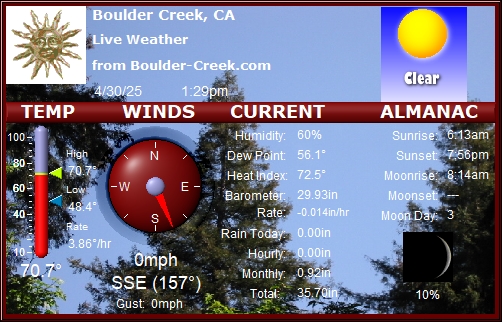
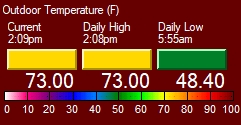
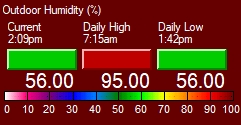
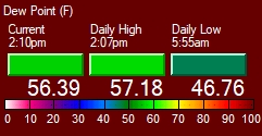
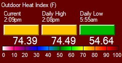
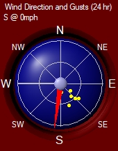
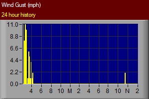
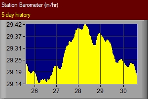
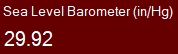
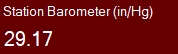
Current
Temperature, Humidity, Wind and Pressure |
|
|
|
|
|
|
|
|
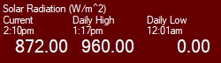
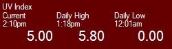
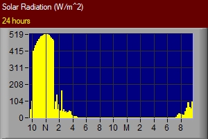
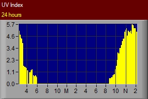
Current Solar Radiation and UV Index |
|
|
| |
* Mid-day drops is due to the sunlight passing through neighboring trees. |
|
Air Particle Counters |
|
Outdoors US EPA PM2.5 AQI |
Indoors US EPA PM2.5 AQI |
|
|
|
|
Loading PurpleAir Widget...
|
Loading PurpleAir Widget...
|
|
| |
| |
| Temperature Converter Utility - Convert between Fahrenheit and Celsius .... |
|
Mobile Weather Report for your PDA and Smartphone! |
|
Checkout This Hour's
Detailed Weather Observations and Calculations ....
|
|
| Visits to Boulder Creek
Weather |
|
|
| Copyright © 2020 All
rights reserved Boulder-Creek.com. |
| Unauthorized duplication
or distribution of pages and weather data is prohibited. Data requests are available. |
| Never base
important decisions on this or any weather information obtained from the
Internet! |
| |
|
| |
| Send comments to webmaster@boulder-creek.com |
| Revised:
26 Dec 2010 00:28 -0800
|
| Top |
| |
| |
| |