The following are local
personal weather stations that owners are thoughtfully sharing their
data with Weather Underground for the
Boulder Creek locale. Due to the mountainous terrain, weather
conditions can vary greatly which is frequently reflected in data
collected from these weather stations. Also each station varies in their
rate of sending data to Weather Underground. Click on any station icon
to have it open into a new browser window showing that station's
detailed conditions.
Cresta Vista
West Park and Hiway 9
Forest Springs
N/O Redwood School
Lompico
Quail Hollow
These links
below are, again,
personal weather stations located in and around Boulder Creek. These
stations may or may not send their data to Weather Underground.
The following
links are amateur radio operators that transmit weather reports for
public use.
APRSWXNET
(APRS - Automatic Position Reporting System), and
CWOP, Citizen Weather
Observer Program, provides data collection from individual stations and
makes it available to MADIS (see below).
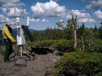
RAWS,
Remote Automated Weather Stations, are typically owned and
maintained by local wildland fire agencies to monitor local fire
danger conditions. These weather stations collect, store, and send
data to the National Interagency Fire Center in Boise, Idaho via the
GOES satellite. These stations are also part of the MADIS project,
Meteorological
Assimilation Data Ingest System.
Fire managers use this
data to predict fire behavior and monitor fuels, resource managers
use the data to monitor environmental conditions. These stations do
not provide current barometric pressure readings. Usually updated
every hour. Link opens into a new browser window. Use the raw data
text link to get last 24-hours. All raw data records day of the
month and times in Zulu (UTC), subtract 7 hours if local time is PDT
(UTC-7), 8 hours if local time is PST (UTC-8).
* closest RAWS near Boulder Creek,
on top of Ben Lomond Mountain
Local NOAA Airport
METAR Stations
In 1996, the Federal
Aviation Administration determined to standardize airport weather
station reports and formatting according to a new international
standard, METAR, which loosely translates to Aerodrome Forecast or
Aviation Routine Weather Report.
The benefits of having the
U.S. standardize to these new code formats are as follows. Hourly and
special observations are used both as stand alone data for the sites and
as inputs to global weather models for both analysis and forecasting. It
is this global use of each small bit of information which drives the
need for standardization. Additionally, the increase in international
flights between the U.S. and other nations from more U.S. locations than
ever before lends itself to developing a more "seamless" international
standard for aviation. Moreover, standardization becomes vital for the
general aviation community for flights from the U.S. to Canada, the
Caribbean Area, and Mexico. For more information see: